
Faculty of Science and Technology
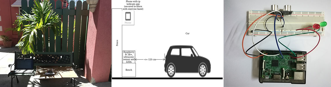
The IoT parking spot monitoring and analysis project utilized IoT, computer vision and web-based technologies to automate data capture, analysis and report presentation.Congestion within Bridgetown is caused by illegal on-street parking due to limited off-street parking facilities and regulation of length-of-stay in authorized parking areas is a measure to address this. The Ministry of Transport and Works of the Government of Barbados needs research to be done to analyse the usage of delivery spots as parking spots, that is, what vehicles are illegally parking in these spots and for how long. Currently, this type of research is done manually. We propose a model that uses IoT to automate the monitoring and analysis of a parking spot. The solution utilizes IoT, computer vision and web technologies (including the Django framework) for data capture, analysis and presentation; along with statistics calculations and presentation.
The device that was designed and custom-built for data capture was reliable. It used a Raspberry Pi, recycled cell phone with an IP webcam app on it and an ultrasonic sensor to monitor the spot. When the ultrasonic sensor detected that an object was closer than 120 cm it triggered the Pi to save the arrival time and capture the image from the phone’s camera. Once the object left the spot the departure time was also saved. The arrival and departure times were correct in all tests and the image captured the triggering object.
The analysis module uses computer vision to locate and classify the vehicles into broad groups (such as ‘car’) as well as more specific groups (such as ‘sports car’); identify the license plate number and the colour of the vehicles. Two analysis algorithms/libraries, ImageAI (IAI) and Plate Recognizer (PR), were evaluated. They can both locate and classify vehicles, but IAI demonstrated higher accuracies than PR, so it can continue being used for object detection and prediction. However, extra modules for license plate location and identification are needed (either PR (this is its primary purpose) or a custom built one) and for colour identification, since IAI only deals with object classification.
A Django web application was built to handle data and statistics presentation and to allow a more user-friendly way to interact with the analysis script (provides a graphical user interface (GUI) rather than making the user run the script from the command line). The presentation section makes it easier to view and search through the data as opposed to having to look through a bunch of text files produced by the analysis script. The current statistics section is specialized for use in this project but can be changed to be more business focussed and less research focussed. Currently it shows accuracies, but it could be changed to just show the raw counts of the detections (number of entries per day, durations, vehicle types, colours). By identifying a vehicle by its license plate, you can also get counts of how often a particular vehicle parks in the spot. Modules could be added to automatically produce reports using the displayed data.
This system can be integrated into other systems. For example, if it’s being used to monitor a spot designated as a special zone (delivery zone for example), it can be integrated into an automated ticketing system for vehicles parking in the spot illegally.
Not published but deliverables including the paper and code can be found at: https://docs.google.com/document/d/1VerTnqA9BFY_Id4MwWgxFcQz4T3L5yt9lrEHwzO9EUY/edit?usp=sharing


